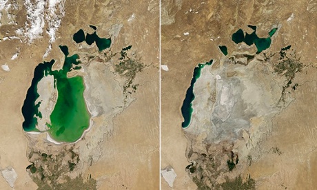
An area of the Central Asian inland sea – once the fourth largest in the world – was left parched in August, according to Nasa photographs. The interactive watch of the Aral Sea’s eastern basin disappear and the text can be accessed at the Guardian.
Until the 1960s, the Aral Sea was fed by two rivers, the Amu Darya and Syr Darya, which brought snowmelt from mountains to the southeast, and local rainfall. But in the 1960s the Soviet Union diverted water from the two rivers into canals to supply agriculture in the region.
With the loss of water, the lake began to recede and its salinity levels began to rise. Fertilizers and chemical runoff contaminated the lake bed. As the lakebed became exposed, winds blew the contaminated soil onto the surrounding croplands, meaning even more water was needed to make the land suitable for agriculture, according to an Earth Observatory release.

The Aral Sea in 2000 on the left and 2014 on the right. Photograph: Atlas Photo Archive/NASA
